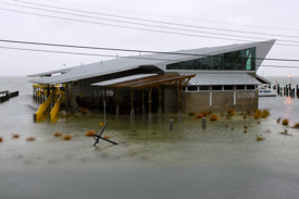
Sandy produces only minor flooding at VIMS
Recent facility upgrades help minimize any damage
The Virginia Institute of Marine Science experienced only minor flooding during the recent passage of Hurricane Sandy, with water levels about a half a foot lower than experienced during the passage of Hurricane Irene in late August of 2011.
The most notable aspect of the storm, says VIMS emeritus professor John Boon, was its duration, with elevated water levels persisting through four successive high-tide cycles, from the evening high tide on Saturday, October 27th through the morning high tide on Monday, October 29th.
Boon established and operates the Tidewatch forecast system at VIMS, which measures and forecasts the difference between the predicted astronomical tide and observed water levels at 10 locations within Chesapeake Bay and along Virginia's seaside Eastern Shore.
Preliminary data from the Tidewatch system show waters level 2.68 feet above the highest astronomic tide at the Yorktown Coast Guard Training Center during Sandy, compared to 3.26 feet of “extratidal” water during Irene. The Yorktown Coast Guard Training Center is the closest official tide station to the VIMS campus in Gloucester Point.
Dr. Woody Hobbs, Director for Operations, Support & Special Projects at VIMS, says flooding on VIMS’ Gloucester Point campus was limited to the area surrounding the Boat Basin, with reports of about a foot of water on the ground during the high tide cycle on Monday morning, October 29th. That brought a few inches of water into two older, wood-fame structures.
“Water barely got into our Dive Locker, with only some of the floor getting wet,” says Hobbs. “There were about 8 inches of water in our old boat repair shed. All in all, Sandy was less of a problem than Irene.” VIMS’ Oyster Hatchery and its new Field Support Center both remained completely dry.

Hobbs credits VIMS Field Operations crew—especially John Oldfield, Matthew West, Paul Oliver, Todd Nelson, Wayne Reisner, and Sharon Miller—with helping to minimize any damage. He says “They had picked almost everything up off the floor on Friday, pulled all of the smaller vessels out of the water and secured them on their trailers, and moved other rolling stock to safer, higher areas.” Captains Durand Ward and John Olney secured VIMS’ flagship research vessel, the 65-foot Bay Eagle.
Wind
Sandy generated only moderate winds in the vicinity of VIMS, with NOAA's CO-OPS station at the Yorktown Coast Guard Training Center recording a short period of 30-40 mph sustained winds from the north-northwest on Sunday evening between 8-10 pm, and a longer period of sustained 30-mph northeasterly winds from noon through midnight on Monday. The highest gust—48 mph from the northeast—was recorded shortly before noon on Monday, October 29.
 The
relatively low wind speeds recorded at VIMS during Sandy—plus their northerly
direction, putting the VIMS campus on the York River’s lee shore—meant little
wave-induced erosion of local shorelines.VIMS’ newly developed
shoreline, completed in 2010, weathered the storm with no apparent effect. The
shoreline—designed by Scott Hardaway of VIMS’ Shoreline
Studies Program—uses stone breakwaters, sand, and native plants to
protect the VIMS shoreline and campus from storm tides and waves.
VIMS Dean and Director John Wells says the new shoreline, Seawater Pier, and Field Support Center “all performed as designed, helping us in this case to escape any noticeable damage.” The new concrete pier—completed in 2011 after the loss of successive wooden piers to hurricanes Isabel and Ernesto—sits 13 feet above mean sea level. The Field Support Center—completed in 2010—is elevated 10 feet above mean sea level.
VIMS’ Eastern Shore Lab
VIMS’ Eastern Shore Laboratory in the seaside village of Wachapreague experienced higher wind gusts and a greater storm surge during Sandy’s passage, but also suffered no significant damage to any facilities or vessels.
ESL Director Mark Luckenbach says “there was some minor flooding in a few of our lower lying buildings, but we had previously elevated all important items above floor level. We did not lose power, but were prepared with gasoline powered pumps and generators had that occurred.”
Luckenbach credits the lack of significant damage to good preparation and planning. “Our new seawater lab and Seaside Hall replacement are elevated and designed to withstand storms,” says Luckenbach, “and they both held up perfectly.”
Like Hobbs, Luckenbach also acknowledged staff for helping to minimize any damage. “As with most storms,” he says, “we had several days to prepare. We pulled all our vessels out of the water and moved them, along with our trucks, to higher ground. We secured all outside seawater tables and tanks, disconnected plumbing connections that are subject to breaking when buffeted by wind and waves, and boarded up appropriate doors and windows.”
Luckenbach adds that ESL staff also used past experience to plan ahead for the storm’s aftermath. “We spent a few hours on Friday putting up a chicken wire fence around parts of our property to block the Spartina detritus and other debris that is typically deposited by storms,” he says. “That saved us a day or more of debris clean up.”


