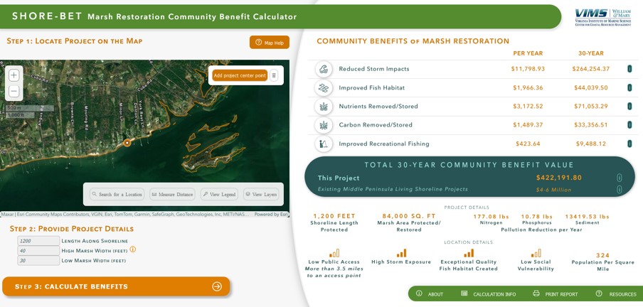
SHORE-BET: Marsh Restoration Coastal Benefit Tool

SHORE-BET: MARSH RESTORATION COASTAL COMMUNITY BENEFIT TOOL is an interactive web-based tool that calculates gained ecosystem and community benefits for marsh restoration projects. This tool is intended to support planning, reporting, and restoration prioritization.
SHORE-BET calculates the economic value of select key coastal community benefits to be gained by protecting marshes and using living shoreline techniques that restore marshes. This tool helps to account for these ecosystem services so that coastal communities can be better informed when making decisions impacting their environment, economy, and overall quality of life. The geographic focus of this is the counties along the Chesapeake Bay within the Middle Peninsula, Virginia (Gloucester, Mathews, Middlesex); however, the approaches behind the tool can be transferred to other regions.
 SHORE-BET - https://cmap22.vims.edu/ShoreBet/
The SHORE-BET tool
- Description: Assigns a dollar value to select key ecosystem services provided to coastal communities by marshes and using living shoreline techniques that restore marshes.
- Ecosystem services are direct and indirect benefits to people provided by nature.
- The ecosystem services included in the total community benefit value assigned, include: reduced storm impacts, improved fish habitat, reduction/storage of nutrients, reduction/storage of carbon, and improved recreational fishing.
- This tool helps answer the following questions:
- How beneficial are marshes and living shorelines to my community in dollars?
- What quantifiable impact does a marsh or living shoreline have to my community?
- How hard does a marsh or living shoreline “work” for me and my community?
- What would it mean for marsh in my community to be reduced or disappear? At what cost would it come to the community?
- Intended use: This tool was designed to calculate an estimate of the benefits communities receive from existing marshes and restoring marshes with living shorelines techniques. The resulting dollar values are intended to inform planning and restoration prioritization efforts and support communications about the importance of these benefits.
- Example of use
- This tool can be used to:
- Develop grant proposals for living shoreline implementation.
- Prioritize the location of living shoreline implementation.
- Prioritize the protection of existing marshes.
- Communicate the value of planned or existing living shorelines.
- The map can display:
- Existing living shoreline projects. This layer can be used to help identify shoreline locations with existing living shorelines.
- Public access points. This layer can be used to help prioritize shoreline restoration and marsh protection sites; the closer a site is to a public access point, the greater the number of people that may enjoy recreational benefits provided by marshes, such as fishing.
- Parcel boundaries. This layer can be used by residents to determine the value of benefits associated with marshes and living shorelines on their property.
- This tool can be used to:

This research was supported by The National Oceanic and Atmospheric Administration under Grant Number NA21NMF4570524-T1-01.
