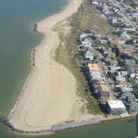
(WIL) Willoughby Spit
Location:
Chesapeake Bay, City of Norfolk, Virginia
Site Parameters
- Coast Type: Headland
- Body of Water: Chesapeake Bay
- Shore Direction of Face: North
- Shore Type: Beach
- Average Shore Height: 8 feet
- Average Fetch: 33 nautical mile
- Distance to 6ft Contour: 300
- Date Installed: August 1990
- Type: Headland Breakwaters
- Number of Breakwaters: 3
- Number of Bays: 2
Land Use: Public Beach
Ownership: City
Problem: Sand transport over the terminal groin
Purpose: Shore protection and enhance recreational beach area
This breakwater project at the westernmost end of Willoughby Spit was the first of several projects in Norfolk that are part of the City's long-term strategic plan along a dynamic Chesapeake Bay shore front. A fetch exposure to north of over 80 miles and a significant ocean wave component during storms leads to a high rate of sand transport toward the west along Norfolk's Chesapeake Bay shore. At the terminus of Willoughby Spit, sand moves over the terminal groin. Two headland breakwaters were constructed in 1988 to halt the transport of sand off City property. Over time, the breakwater systems completely fill with sand which is dug out and recycled updrift to eroding sections of the shore.
