Barrier-island migration drives large-scale marsh loss
Holistic study of coastal ecosystem reveals rapid response to climate change
If you’ve visited the Outer Banks or other barrier islands, you’ve likely experienced their split personalities—places where high waves can pound the sandy ocean shore while herons stalk placid saltmarsh waters just a short distance landward.
New research by a team from William & Mary and its Virginia Institute of Marine Science shows that these seemingly disparate ecosystems are in fact closely coupled, and that rapid landward migration of barrier-island sands is leading to large-scale loss of adjacent saltmarshes. Their study—recently published online in Geology—focuses on the pristine barrier islands of Virginia’s Eastern shore, but is likely applicable to similar barrier-island systems worldwide.
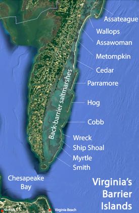
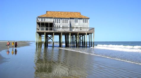
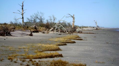
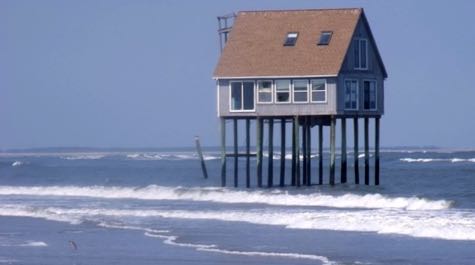
The team’s research shows Virginia’s barrier islands are eroding or migrating landward at 3 to 18 feet per year. They estimate the landward migration consumes at least 60 acres of back-barrier saltmarsh annually, and has buried almost 8,000 acres of these saltmarshes since 1870—nearly 10% of Virginia’s historical acreage of back-barrier saltmarsh habitat. Loss of marshes is of significant environmental concern given their beneficial role as feeding grounds for waterfowl, nursery grounds for numerous marine species, and ability to absorb carbon, pollutants, and wave energy.
Lead author Charlie Deaton, who conducted the research while an undergraduate in W&M’s Department of Geology, says the team arrived at their results, “by digitizing and analyzing hundreds of maps and photographs extending back to 1851, and comparing these with LiDAR data showing recent shoreline positions.”
Study co-author Dr. Chris Hein, an assistant professor at VIMS, attributes the islands’ changing shorelines to the action of coastal storms. “Hurricanes and nor’easters cause both beach erosion and barrier migration,” says Hein. “Sea-level rise and other factors play a contributing role by setting the conditions for storm surge to erode the shoreline and carry barrier-island sands landward into the marsh.”
The study’s third co-author, VIMS assistant professor Dr. Matt Kirwan, notes that, “Virginia’s barrier islands are exposed to some of the highest rates of relative sea-level rise along the U.S. Atlantic Coast.” A 2015 VIMS study puts the rise rate at Kiptopeke on Virginia’s Eastern Shore at ~3.7 millimeters per year over the last 50 years. That’s a tenth of an inch annually, or more than half a foot of sea-level rise since the mid-1960s.
Observations and modeling
The research team’s study reflects a growing interest in how back-barrier saltmarshes might stabilize or destabilize barrier islands. Says Hein, “Coastal geologists have historically treated the evolution of saltmarshes and barrier islands separately, but in the past decade we’ve really begun to recognize how changes in one can affect the other.”
One hypothesis, based on both computer models and field observations, is that storm-driven transport of sands over a barrier island and into marshes helps the latter keep vertical pace with rising seas, while the presence of marsh close behind the barrier island stabilizes the island and acts to slow its landward migration.
An alternative, conceptual model suggests that rising seas are drowning back-barrier marshes. Under this scenario, because more water can fill coastal bays as the tide floods in, more water needs to drain from them as the tide ebbs out. This requires larger cross-barrier channels to accommodate the increased ‘tidal prism;’ these in turn carry barrier sands into flood- and ebb-tide deltas—effectively removing the sediments the barrier islands need to survive. Starved of sand, the shoreline retreats, and the barrier island grows narrower, or migrates even faster.
The findings of the current research contradict this concept of a ‘runaway transgression.’ “We found that in Virginia’s barrier islands, increased rates of shoreline retreat actually correlate with a decreased tidal prism,” says Hein. “The tidal prism is commonly decreasing because the barrier islands are migrating so quickly that they’re shrinking the area between them and the mainland for water to fill during high tide.”
Deaton, Hein, and Kirwan say the primary coupling between Virginia’s barrier islands and back-barrier environments is the islands’ rapid landward migration. They estimate this accounts for more than half the region’s historical decrease in saltmarsh area, and say migration-induced saltmarsh loss can also be expected in similar mixed-energy barrier systems, such as those in South Carolina and New Jersey, as well as in Germany and along other distant shores.
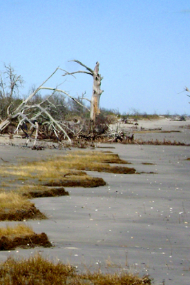
The researchers attribute the remaining loss of saltmarsh area to various back-barrier processes. A major factor in larger coastal bays is erosion of the marsh edge by wind-driven waves.
The research team is careful to distinguish landward migration of a barrier island from the retreat of its shoreline. “We find that large-scale loss of back-barrier saltmarsh area is specific to islands undergoing landward migration, and not simply shoreline erosion,” says Hein. “A barrier island that is migrating landward can still maintain its width; one suffering from shoreline erosion will invariably grow narrower, and eventually start to migrate in a very narrow form.”
The researchers are most concerned with saltmarsh loss in areas backed by coastal cliffs or human obstructions such as bulkheads or levees. Says Hein, “Landward migration of barrier islands far outpaces migration of the marsh into uplands. Marsh loss is of particular concern in areas where steep uplands prevent the marsh from migrating onto mainland shores, as this prevents the system from balancing losses to landward migration of the barrier island.”
“Regardless of a marsh’s ability to keep pace with sea-level rise by growing vertically,” adds Kirwan, “large-scale marsh loss may be inevitable as barrier systems worldwide equilibrate to sea-level rise by migrating landward.”
Funding for this study was provided by the National Science Foundation's Long Term Ecological Research program and Coastal SEES program (grants 1426981 and 1325430).

