National Program
Overview
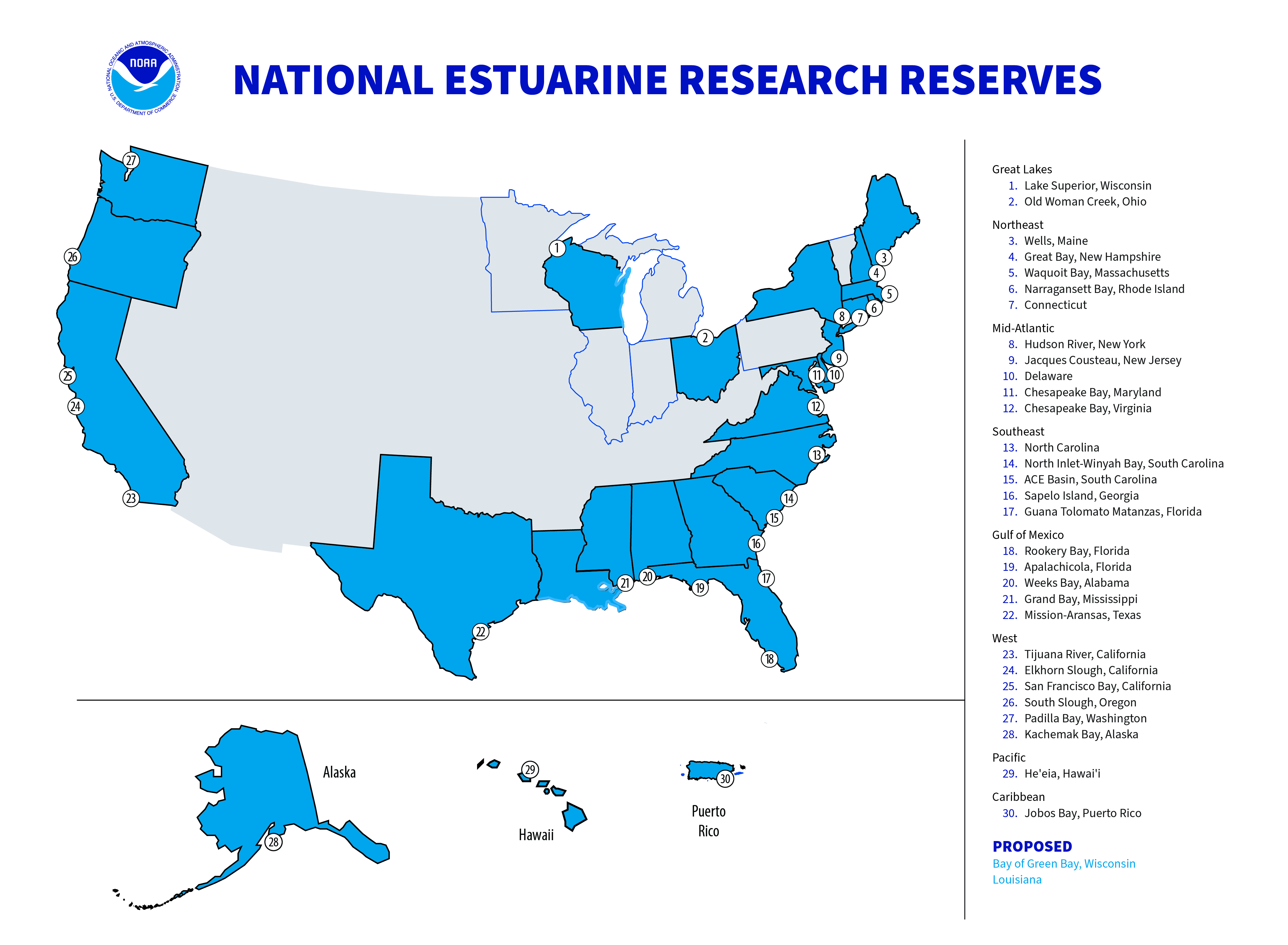
Established in 1972 under the Coastal Zone Management Act (CZMA), the National Estuarine Research Reserve System (NERRS) is a network of coastal sites designated to protect and study estuarine systems. Place-based reserve programs are designed to address the major challenges of coastal management by integrating innovative science and environmental monitoring, resource stewardship, K-12 education and professional training. The reserve system currently protects more than 1.4 million coastal and estuarine acres in 30 reserves located in 24 states and Puerto Rico.

NOAA and NOAA Associated Partners
In addition to the individual reserve sites, the NERRS cooperates with many NOAA based programs to support its mission.
NOAA's Office for Coastal Management oversees implementation of federal mandates and provides technical assistance to federally approved state programs.
NOAA’s National Centers for Coastal Ocean Science (NCCOS) conducts and supports research, monitoring, assessments and technical assistance to meet NOAA’s coastal stewardship and management responsibilities.
NOAA's National Geodetic Survey (NGS) defines and manages the National Spatial Reference System, which provides the foundation for transportation and communication, mapping and charting, and a multitude of scientific and engineering applications.
NOAA’s Center for Operational Oceanographic Products and Services (CO-OPS) provides the national infrastructure, science and technical expertise to monitor, assess and distribute tide, current, water level, and other coastal oceanographic products and services that support NOAA's mission of environmental stewardship and environmental assessment and prediction.
NOAA’s National Weather Service (NWS) provides weather, hydrologic, and climate forecasts and warnings for the United States, its territories, adjacent waters and ocean areas. NWS data and products form a national information database and infrastructure which can be used by other governmental agencies, the private sector, the public and the global community.
NOAA’s Chesapeake Bay Office (CBO) works to help protect and restore the Chesapeake Bay through its programs in fisheries management, habitat restoration, coastal observations and education, and represents NOAA in the Chesapeake Bay Program.
Virginia’s Coastal Zone Management Program is part of the National Coastal Zone Management Program, a voluntary partnership between National Oceanic and Atmospheric Administration (NOAA) and U.S. coastal states and territories authorized by the Coastal Zone Management Act. The Department of Environmental Quality (DEQ) serves as the lead agency for Virginia's networked coastal zone management program and helps agencies and localities develop and implement coordinated coastal policies and solve coastal management problems.
Virginia Sea Grant facilitates research, educational and outreach activities promoting sustainable management of marine resources. We are part of a larger network of Sea Grant programs housed in 33 colleges and universities around the country.
NOAA’s Sea Grant is a nationwide network of 33 university-based programs that work with coastal communities. The National Sea Grant College program engages this network of the nation’s top universities in conducting scientific research, education, training and extension projects designed to foster science-based decisions about the use and conservation of our aquatic resources.
Other Key Partners
The Chesapeake Bay Program leads and directs the restoration of the Chesapeake Bay with partners from federal and state agencies, local governments, non-profit organizations and academic institutions.
The Chesapeake Bay Sentinel Site Cooperative (CBSSC) is a collaborative group of scientists, coastal managers, decision makers, and community liaisons across Maryland and Virginia who: 1) work together to measure the impacts of sea level rise in the Bay; 2) work with partners to apply scientific findings produced at sentinel sites to help communities prepare for coastal flooding and other effects of changing climate conditions; and 3) work in partnership with coastal managers, decision makers, and community liaisons. CBSSC is one of the five sentinel site cooperatives within the national NOAA Sentinel Site Program.
NERRS Central Data Management Office (CDMO) is located at the University of South Carolina's Belle W. Baruch Institute for Marine Biology and Coastal Research and the North Inlet-Winyah Bay, SC NERR. The purpose of the CDMO is to support and improve the NERRS System-Wide Monitoring Program through all aspects of data and metadata management, maintaining online data and information accessibility, and providing technical support services.
The National Estuarine Research Reserve Association (NERRA), a national nonprofit organization, was established in 1987 to promote and advance the NERRS. NERRA is dedicated to the protection, understanding and science-based management of our nation’s estuaries and coasts. The NERRS relies on the support of NERRA to strengthen and expand its successful programs, and to enable its network to better address growing challenges to our nation’s estuaries and coasts. NERRA works with Congress, NOAA, and public and private partners to increase support for research, monitoring, education and stewardship within the NERRS. NERRA also provides public education and outreach to improve awareness and understanding of the importance of estuaries and coasts.
Virginia's Department of Environmental Quality administers state and federal laws and regulations for air quality, water quality, water supply and land protection. In addition, other programs cover a variety of environmental activities, such as improving the ability of businesses and local governments to protect the environment, and offering technical and financial assistance for air and water quality improvements. Through its six regional offices, DEQ issues permits, conducts inspections and monitoring, and enforces regulations and permits.

